One of the premier hiking destinations in the United States, Moab is full of geological juxtapositions carved out over centuries.
You’ll experience arches towering hundreds of feet above you, making you feel comparatively minuscule. Then, conversely, you’ll find magnificent vistas full of fissures hundreds of feet deep. Sometimes you’ll see both at the same time.
Moab is an adventurer’s paradise and a great Utah weekend getaway. With two of the best national parks in the US on its doorstep – Arches National Park and Canyonlands National Park, it’s not surprising hiking is one of the most popular things to do in Moab.
We’ve put together a guide to six great hikes near Moab that will help you experience the breadth of landscapes in and around Moab.

The 6 Best Hikes Near Moab, Utah for Adventure Lovers
Moab is home to two national parks in Utah – Arches National Park and Canyonlands National Park – both part of the “Mighty Utah 5” which makes a fantastic road trip itinerary. Both offer completely different experiences and landscapes worth spending a full day exploring. More if you have the time.
Outside the two national parks, which see the lion’s share of visitors to the area, there are also a couple of places worth visiting where you’ll find fewer crowds and the same jaw-dropping natural beauty.
Here are six great hikes near Moab to add to your Utah adventure.

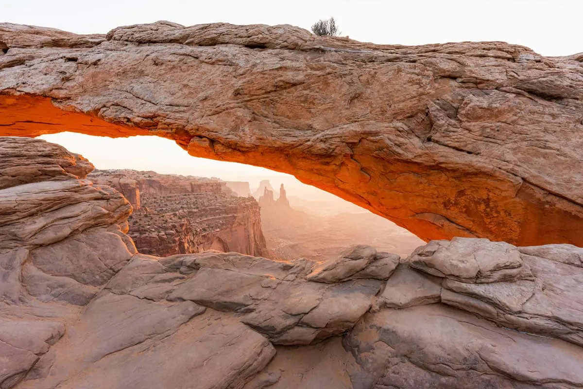
Arches National Park Tip: Enhance your experience in Arches National Park with a Self Guided Driving Tour App. Simply download the tour to your phone which includes:
- Self-guided tour via an app
- Live GPS map on your phone
- Audio narration
- Written text explanations
See here for full self guided tour details and app download.
Delicate Arch
The most popular hike in Arches National Park for a good reason. It’s relatively easy at just three miles roundtrip (with 500 feet of elevation gain), and Delicate Arch itself is perched atop a mesa with views across the park all the way to the La Sal Mountains beyond.
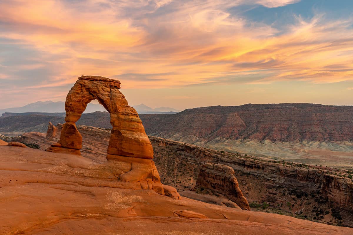
The hike begins from the Delicate Arch Trailhead just off of Arches Scenic Drive, the road that runs all the way through the park. The trail starts level and begins to climb once you hit a giant slab of slickrock – make sure you wear hiking shoes with good traction.
At the top of the slickrock, it’s a short hike to the arch on a narrow stretch of trail that hugs a cliff with a steep drop off on the other side. If you’re nervous about heights, stick to the inside of the trail closest to the wall.
You don’t get your first glimpse of Delicate Arch until you’re essentially on top of it. You’ll emerge onto a bowl, and the arch stands on the far end.
You can enjoy the views from a seat either on the opposite side of the bowl from the arch (closest to the trail) or head across the bowl to the left for a nice view of the arch from the east. A good spot to take your picture standing under the arch.
When you’re done, head back downhill the way you came. Be careful on the slickrock, which can be slippery heading down.
Sunrise & Sunset at Delicate Arch
Because of its orientation, this hike is best done in the late afternoon or at sunset. The setting sun lights up the arch in a deep orange-red color as it dips below the horizon. The only downside to sunset is that you’ll potentially encounter lots of people all with the same idea.
Sunrise means fewer crowds, but as soon as the sun comes up, the arch will be backlit, which is not the best for good pictures.
Moab Tour Tip
See more of Arches National Park and Canyonlands National Park with a tour from above.
Arches National Park Airplane Tour
Snag yourself a guaranteed window seat for a comprehensive birds-eye tour of Arches National Park. Enjoy unobstructed views of The Arches National Park before flying up the Colorado River to see the dramatic spires of Fisher Towers on board a comfortable aircraft with guided commentary from your pilot. See here for full tour details.
Arches Backcountry Helicopter Flight
Depart Canyonlands Field Airport for a private helicopter tour into the Behind the Rocks Wilderness area to see remote arches and amazing red rock formations, some only visible from above. The tall spires of Determination Towers and the expansive Gemini Bridges, fly over the southern end of the Moab Valley to Castle Valley, to see the amazing Castleton Tower and see jeeps galore on the extensive 4×4 trails and the Colorado River canyon. See here for full tour details.
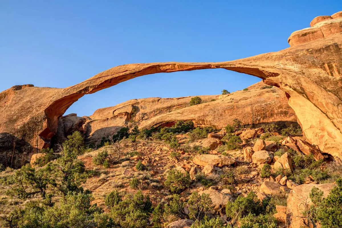
Devils Garden
While Delicate Arch gets the most fanfare, Devils Garden is the premier hike in Arches National Park. It’s also a customizable hike to suit your style:
- A quick out-and-back hike to the towering Landscape Arch (two miles, 250 feet elevation gain).
- A mid-range hike past Landscape to Navajo, Partition, and Double O Arches (four miles, 570 feet elevation gain)
- Complete the entire loop passing seven different arches and returning via the “Primitive Trail,” which entails a little route-finding (follow the cairns – the stacks of rocks that mark the trail) and light scrambling.
Devils Garden Loop Hike
The full Devils Garden loop clocks in at eight miles, with 1,100 feet of elevation gain. It’s very exposed with minimal shade, so you need to pack plenty of water and wear sun protection. Heatstroke is not a joke, and you’ll be particularly vulnerable in the summer when temperatures can rise above 100 degrees Fahrenheit in the middle of the day.

This hike begins from the end of Arches Scenic Drive, right across from Devils Garden Campground. If you manage to snag a campsite inside the park, you’ll be able to walk to the trailhead and not have to worry about parking.
There is a huge parking lot for this hike, but somehow it still fills up by the middle of the day. Get there before 9 am if you can, secure a parking spot, and get on the trail before the hottest part of the day.
Do the hike clockwise, starting with Landscape Arch, a towering arch you can only see from afar. Landscape Arch looks like it’s only one bird landing on it away from completely crumbling onto the hillside below.
You used to be able to walk underneath the arch, but over the past decade, several pieces have broken off, so you’ll have to settle for viewing the longest arch in the park from afar.
Not far from Landscape Arch is an offshoot to the left that takes you to two more arches – Navajo and Partition.
Continue along the trail, which takes you onto a narrow ridge with great views in every direction. You’ll eventually arrive at Double-O Arch, which is two arches stacked on top of each other. There’s shade here, which makes it a good spot to grab a snack and some water before you make the journey back to the trailhead.

Tip: Skip the hike out to Dark Angel, which is not an arch, but a rock tower. It adds an extra half mile that isn’t worth the effort. Start along the primitive trail, which heads off to the right.
Primitive Trail is the part of the hike that requires some route-finding and light scrambling, but it’s a well-worn path that hundreds of people do every week – so don’t worry about being alone in the wilderness. There’s an offshoot to the right that climbs up a gulch to Private Arch at about a half-mile in.
Follow the primitive trail back to the Landscape Arch trail, and make a final pitstop at Pine Tree Arch and Tunnel Arch – you’ll find them on an offshoot just 0.2 miles from the parking lot.
Know what to pack for your Moab adventure with our Hiking Vacation Packing Guide
Park Avenue
The closest hike to the park entrance, Park Avenue, might have one of the best views in Arches National Park, but there aren’t actually any arches to be found here. The trailhead is along Arches Scenic Drive, and this makes a great first or last hike of the day.
It’s just two miles out and back with 300 feet of elevation gain. You’ll traverse the floor of a canyon surrounded by some of the park’s most famous rock formations towering hundreds of feet above you on either side.
Start with the viewpoint, which gives you a perspective from above, before descending to the canyon floor to admire the sheer scale of the monoliths from below. You’ll see the Courthouse Towers, the Tower of Babel, and the Three Gossips along the way.
This hike connects two trailheads – the Park Avenue Trailhead and the Courthouse Towers Trailhead so you can customize a combined hike.
- Do an out-and-back hike from the Park Avenue Trailhead descending into the canyon, then climbing back up to the parking lot.
- Or a through-hike, which is a one-mile hike downhill all the way. Doing a through hike requires a second car at the Courthouse Towers trailhead to shuttle you back to your vehicle.
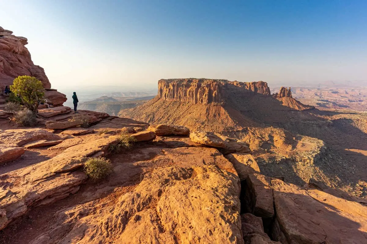
Grand View Point Trail
Grand View Point hike is in Canyonlands National Park’s Island in the Sky District and is a great introduction to the immense scale of Canyonlands. If you only have time for one hike in the park, this should probably be it.
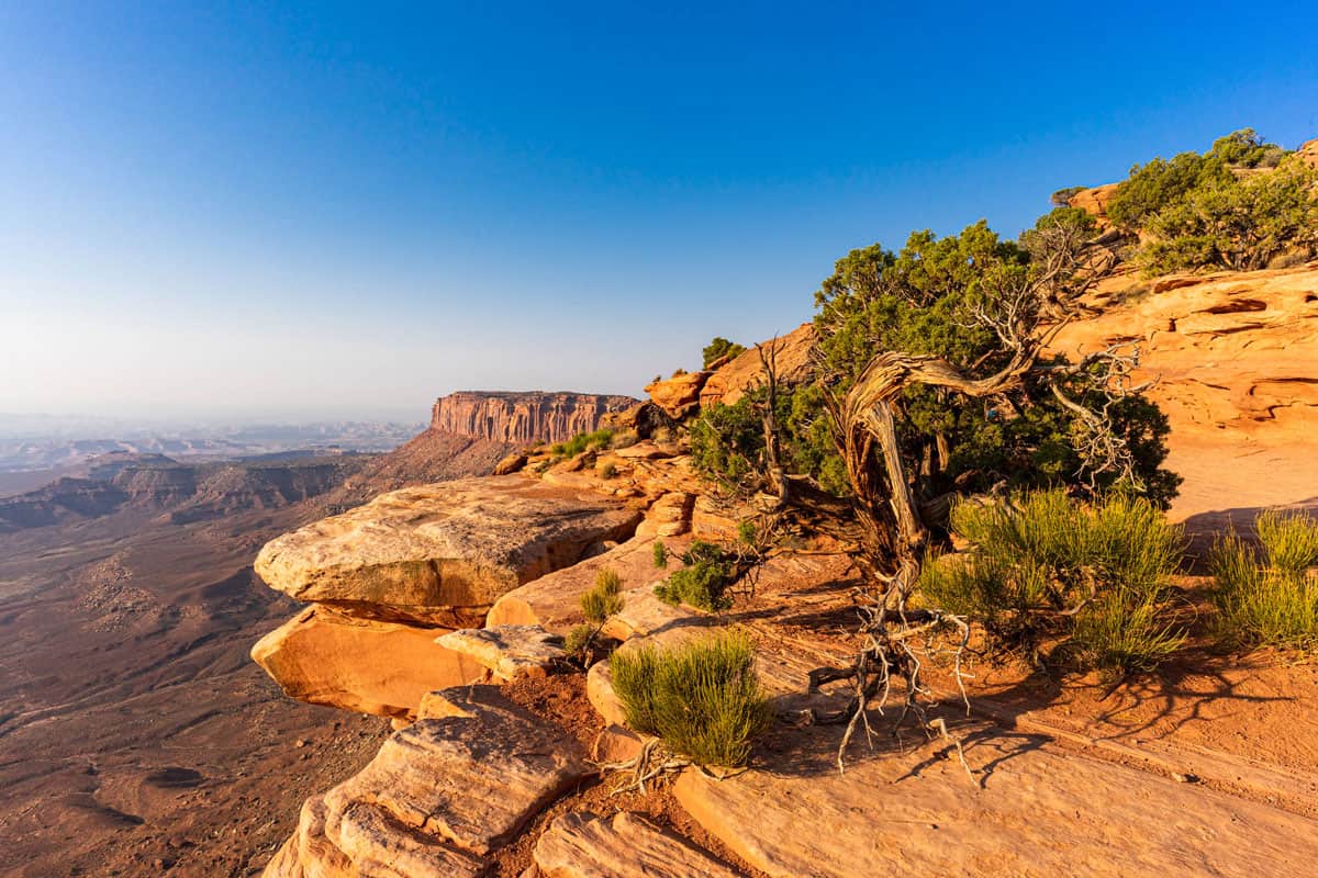

The short two-mile out-and-back hike starts from the Grand View Trailhead at the end of aptly named Grand View Point Road, the main road through Canyonlands’ Island in the Sky region.
The hike itself is mostly flat, following the rim of the mesa out to its edge. From there, you’ll have a panoramic view of the network of canyons forged by the two massive rivers below – the mighty Colorado River and the Green River.
From that viewpoint, you can see Junction Butte, which is an anomaly in that it juts up out of the canyon floor surrounded by a network of fissures caused by hundreds of years of erosion. Ensure to climb up onto the butte at the end of the trail for even better views over the surrounding area.
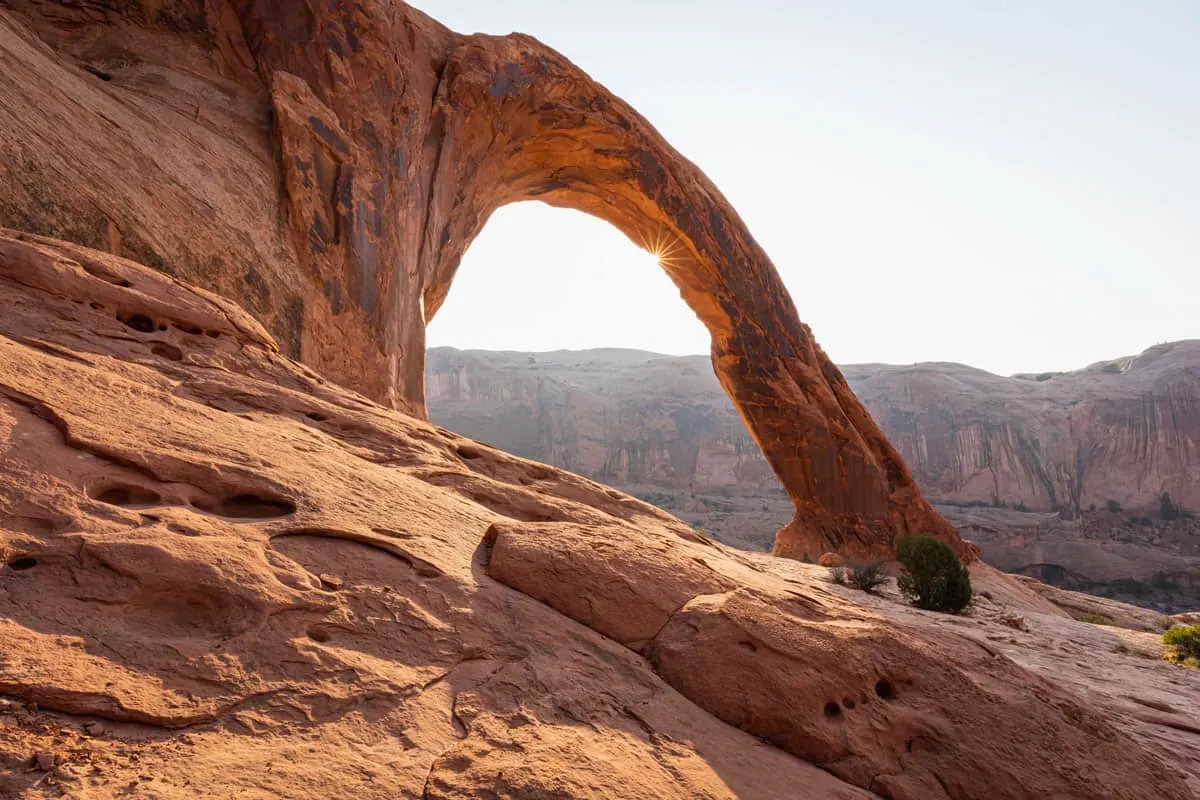
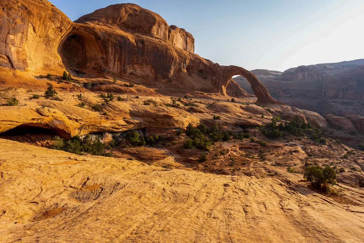
Corona Arch
If it were inside of Arches National Park, this would be one of the most popular hikes near Moab. However, since it’s not, most people never see the incredible 100+ foot tall arch. Only one and a half miles from the trailhead along highway 279 northwest of Moab, it’s a relatively easy hike climbing 500 feet over a mile and a half (three miles roundtrip).
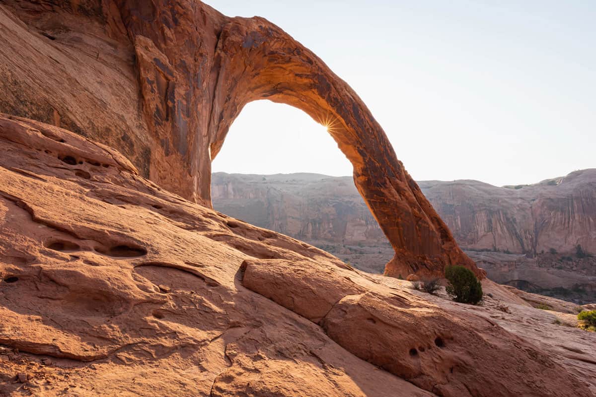
There are a few parts of the hike that err on the moderate side of the easy-moderate spectrum, with some rope-assisted climbing up steep slickrock and climbing a ladder.
The climb onto the plateau to the Corona Arch is worth it as you’ll be treated to sweeping views of the surrounding canyon, both up to the canyon walls and down to the fissures below. Before arriving at Corona Arch, you’ll pass Bowtie Arch, which, as the name suggests, looks like a bowtie.

Corona Arch is the star of the show, though. Pass under the arch to marvel at the structure, and head to the far side of the arch for the best view.
This hike is best in the afternoon around sunset. In the mornings, the sun takes a while to rise over the canyon walls to the east of the arch. In the evening, the setting sun turns the arch a deep red color. Bring a picnic and a sundowner and stick around for the light show.
Do a Combined Corona Arch and Jeep Arch Hike
This hike pairs nicely with the hike out to Jeep Arch (see below), because the trailheads are only a quarter of a mile from each other. In total, the two hikes together are seven miles long. If you’re doing them in the afternoon, be aware that both are exposed and will get very hot.
Tip: Do the hike to Jeep Arch first, then take in the sunset at Corona Arch.
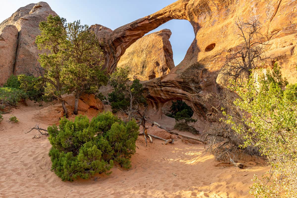
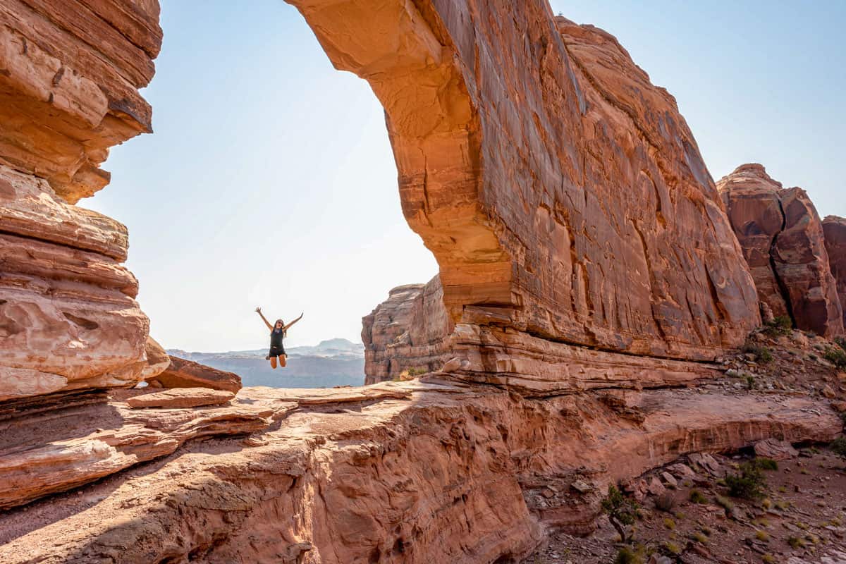
Jeep Arch
Compared to the crowds you’ll probably share Delicate Arch with, it’s possible to be the only people at Jeep Arch.
Jeep Arch is not in either of the national parks near Moab, so many visitors miss it. However, this is just one reason it is a worthwhile hike. The trailhead is immediately adjacent to the trailhead for Corona Arch, which makes these two hikes a nice tandem.
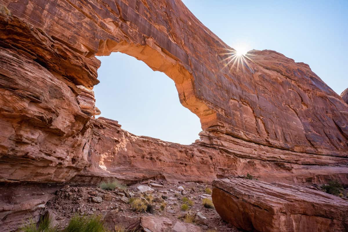

In Arches National Park, you’ll see an awful lot of freestanding arches, like Delicate Arch, Double Arch, and Landscape Arch. Jeep Arch is different – it’s carved out of the canyon wall, which means it’s more like a window. It’s loosely in the shape of a jeep, hence the name, but not everybody sees it.
To get there, start hiking up the tube, which is a drainage pipe (it’s hard to believe there’s ever enough water to fill it in the middle of the desert). Don’t make the mistake of climbing up the hill, where you’ll find railroad tracks and a steep descent back to the bottom on the other side.
The hike is a four-mile loop with 950 feet of elevation gain. It really doesn’t matter which direction you go. Clockwise offers marginally better views of the arch as you approach, but you can get the same view by simply turning around if you choose to go counter-clockwise.
This trail is not well marked, but there are cairns along the trail for you to follow. Download the trail map before you leave Moab, so you have a guide along the way.
The other thing to know is that you won’t see the arch until you’re basically right under it. You can – and should – walk through it, which is the way the loop trail takes you.

Author Bio
Matt Hansen
Matt is the founder of Wheatless Wanderlust, where he and his wife Alysha write about their favorite finds – from unforgettable hikes and national park adventures, to hipster coffee shops and the best gluten free donuts – so that you can plan the perfect trip and discover something new. They spend half of the year on the road living in “Homer,” their temperamental Honda Odyssey, and the other half exploring the Pacific Northwest.